Olpererhütte to Friesenberghaus Day Hike: A Zillertal Classic
High above the Zillertal Valley, the day hike linking Olpererhütte and Friesenberghaus is one of the most scenic alpine routes near Mayrhofen, Austria. Famous for its dramatic suspension bridge views and glacier-fed lakes, this hike combines rugged mountain terrain with postcard-perfect scenery at every turn. Starting near the Schlegeis Alpine Road, the trail climbs quickly into a high-alpine world of granite peaks, turquoise reservoirs, and traditional mountain huts that feel unchanged by time.
While many visitors hike to Olpererhütte for the iconic bridge and turn back, combining Friesenberghaus transforms the outing into a far more rewarding adventure. The trail becomes quieter, the landscapes wilder, and the sense of immersion deeper. Whether you’re chasing alpine views, hut-to-hut experiences, or a challenging but achievable day hike, this route delivers one of the best mountain days in the Austrian Alps. This hike was included as part of an interrailing hostelling trip to Mayrhofen after visiting Munich and before travelling to Vienna.
Planning & Tips for the Olpererhütte – Friesenberghaus Hike
Getting There
- Base town: Mayrhofen, Tyrol
- Trailhead: Schlegeis Stausee (Schlegeis Alpine Road – toll road)
- Access: Drive from Mayrhofen (~1 hour) or Bus services run in summer, but check schedules carefully as return times are limited
Route Overview
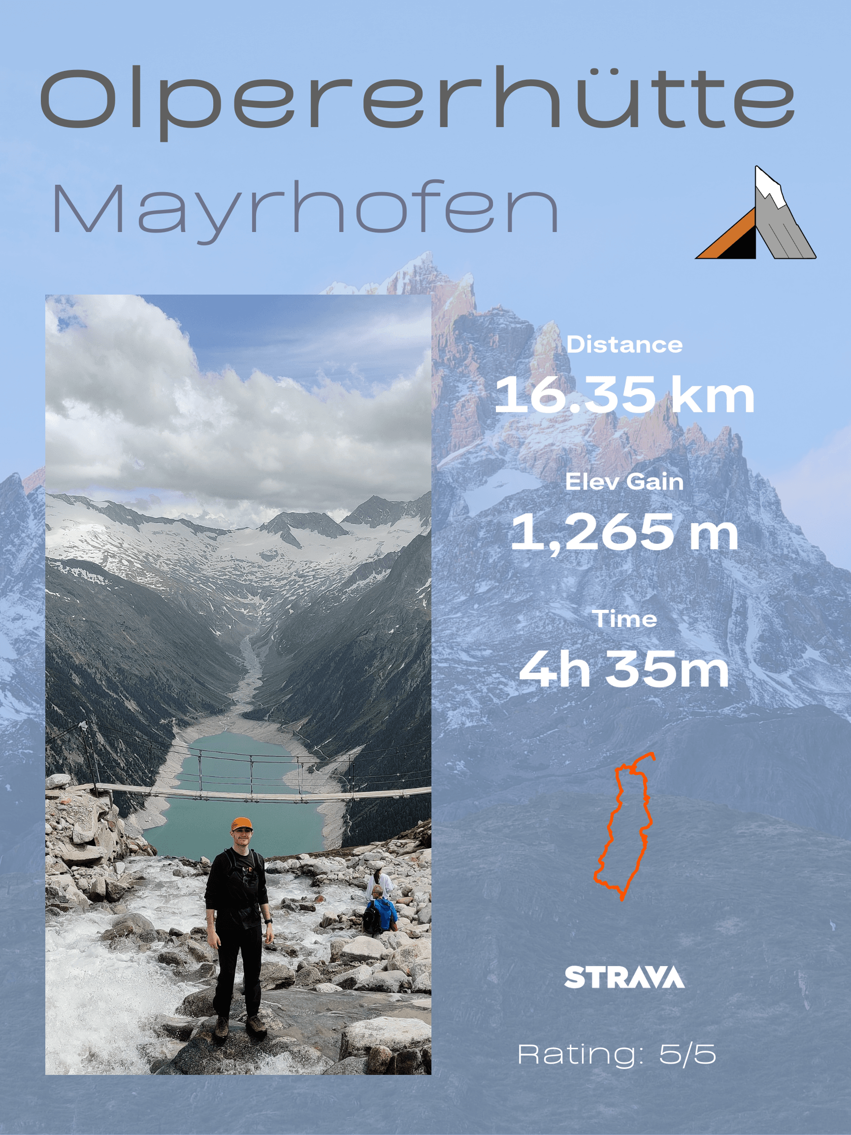
- Distance: ~12–16 km (round trip, depending on route choices and Petersköpfl addition)
- Elevation gain: 1000–1,250 m
- Time: 5–7 hours total
- Difficulty: Moderate to challenging (sustained climbs and exposed alpine terrain)
- Highest point: ~2,400 m or 2700m if adding on Petersköpfl
- Direction: Start from Schlegeis Reservoir, head up to Frisenberghaus, then traverse over to Olpererhütte before descending back to the reservoir.
Best Time to Go
- Late June to September is ideal because in early June, when we hiked, there was snow on the trails higher up, where microspikes and poles would be useful. As expected, July and August give the best weather and are therefore the busiest.
What to Pack
- For a Day Hike, I would use good-quality hiking footwear, a backpack and additional layers as the altitude increases. Whilst I used a simplified version of my usual hiking gear due to this being part of an inter-city hostelling trip, I ensured we both had appropriate hiking shoes and plenty of water. Check out this Hiking Gear List Packing Guide to see the essentials to take.
Food & Mountain Huts
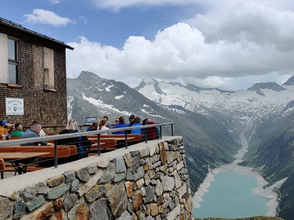
- Olpererhütte: Famous for views and Kaiserschmarrn—expect crowds but open for more of the year.
- Friesenberghaus: Quieter, traditional, and a great lunch stop, but not open early June or late September.
- Both huts accept cash; card payment is not guaranteed
Safety Tips
- Check the weather forecast before you go—storms roll in quickly, and the Alps are unpredictable.
- Stay on marked trails; fog can reduce visibility, and the lack of hikers towards Frisenberghaus means having downloaded maps or navigation is vital (Here is the AllTrails link we used).
- Be mindful of exposure on narrow sections or on snowy traverses.
- Turn back if conditions deteriorate—this is high-alpine terrain
Crowd-Beating Advice
Continue beyond Olpererhütte—crowds thin dramatically after the bridge, with my favourite viewpoint literally a few minutes from the crowds. It’s best to get an early bus to start from the Reservoir before many people arrive, ideally before 8 am. And visiting mid-week will make the hike even quieter.
The Olpererhütte – Friesenberghaus Hike
As featured in The Best Mountain Hikes, Olpererhutte Bridge has exploded in popularity and was one of the primary reasons I wanted to visit Mayrhofen. However, I wanted more of a challenge than the 2-hour hike from the bus straight to Olpererhütte. Instead, we planned to go on the path less trodden over to Friesenberghaus first and then traverse along using this AllTrails. First, we packed our bags and caught a local bus over to Schlegeis Stausee, where the trails began. Mayrhofen is 25 km away from Schlegeisspeicher (Schlegeis Reservoir) and takes around an hour on the 4102 bus.
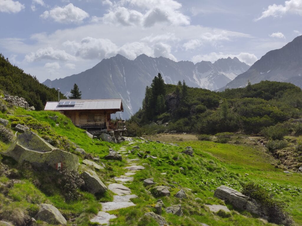
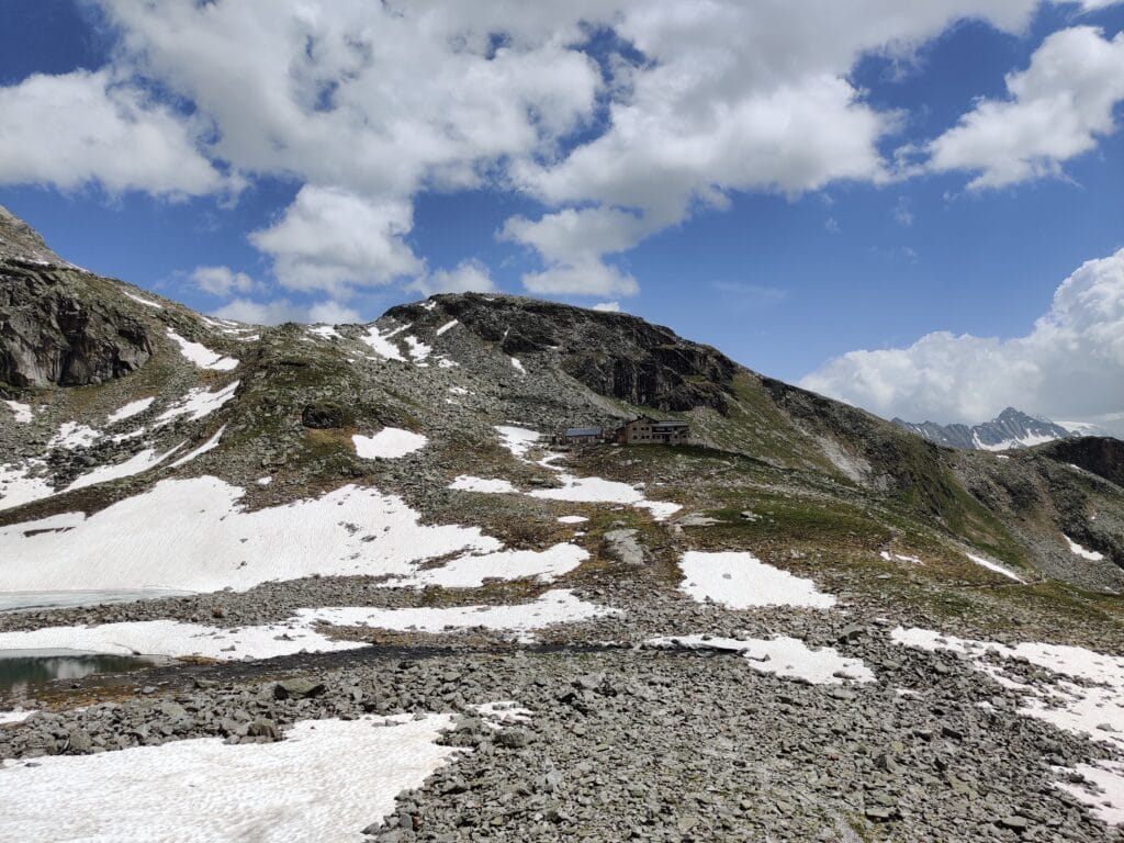
Friesenberghaus
The day was looking promising with some clouds and spells of sun, which created a moody atmosphere. We saw no other hikers for the first few hours up to Frisenberghaus, but it was early June, which is before the season properly opens. The trial wound up in a wooded area, slowly gaining altitude as we approached a small cabin to refill water and look back over the board decks. The far peaks and parallel valleys seemed never-ending, with snow and clouds encompassing them. We climbed up the valley along a stream and over snow patches before reaching Frisenberghaus at 2,477m.
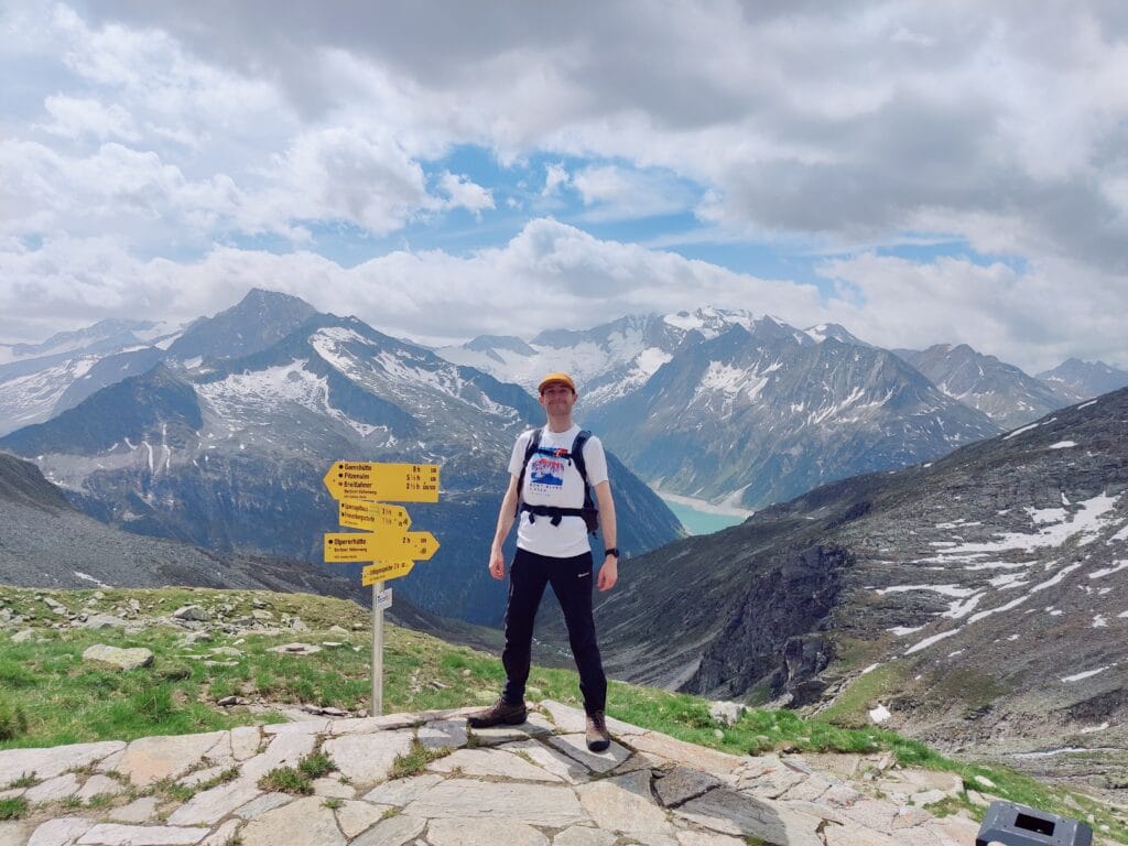
Petersköpfl
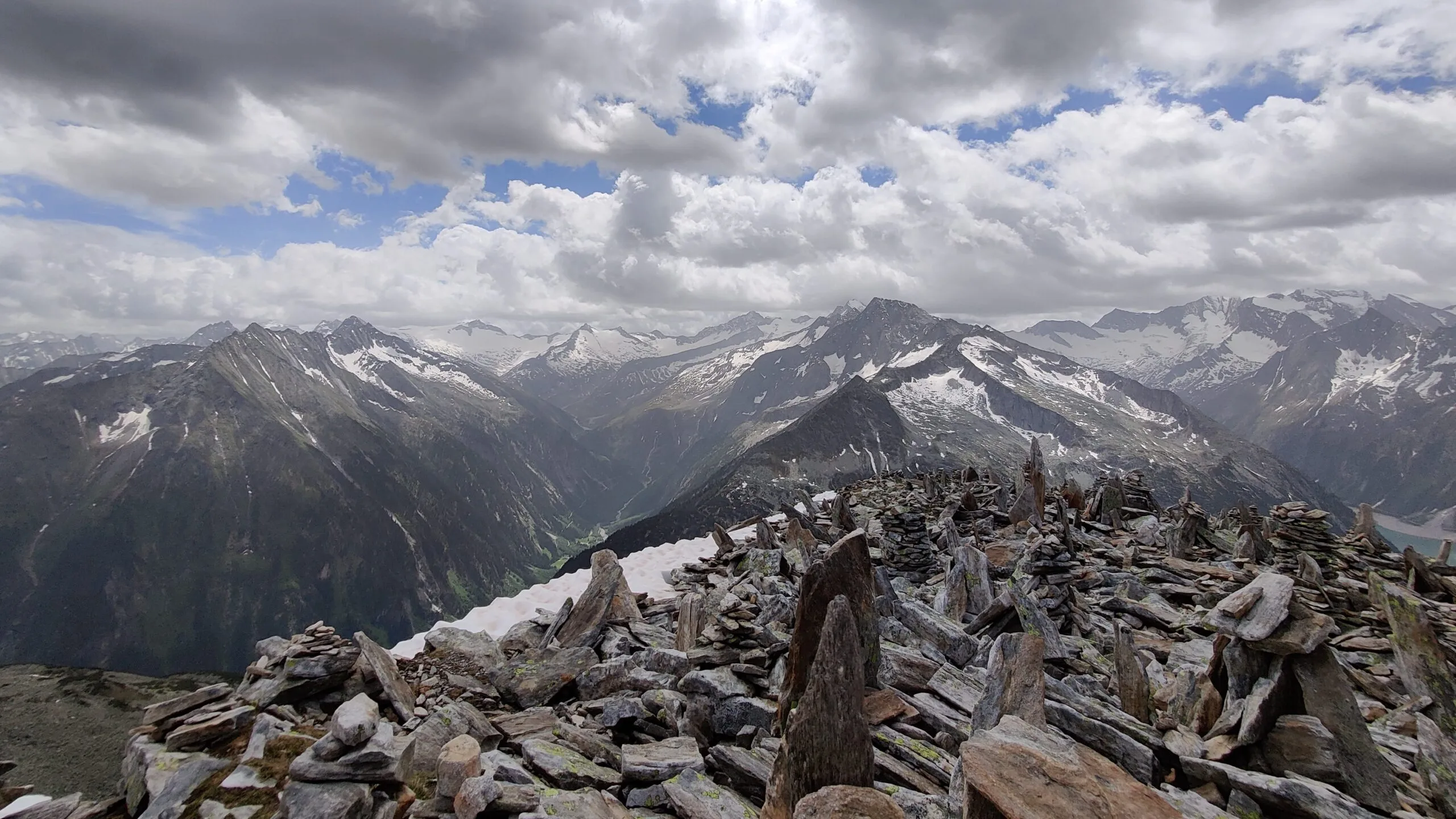
After a short break and photos back along to the reservoir, we continued onto a short scramble up to Petersköpfl. This stands at 2679m and is a jagged rocky summit covered with Cairns or “Steinmänner”. The views across Großer Möseler, Hochfeiler and Hochferner peaks bordering Italy are outstanding! It’s a fun extension from Frisenberghaus, with some minor scrambling to reach the top. At almost 2700m, the altitude was noticeable, but that didn’t stop us from continuing over towards Olpererhutte.
Olpererhütte
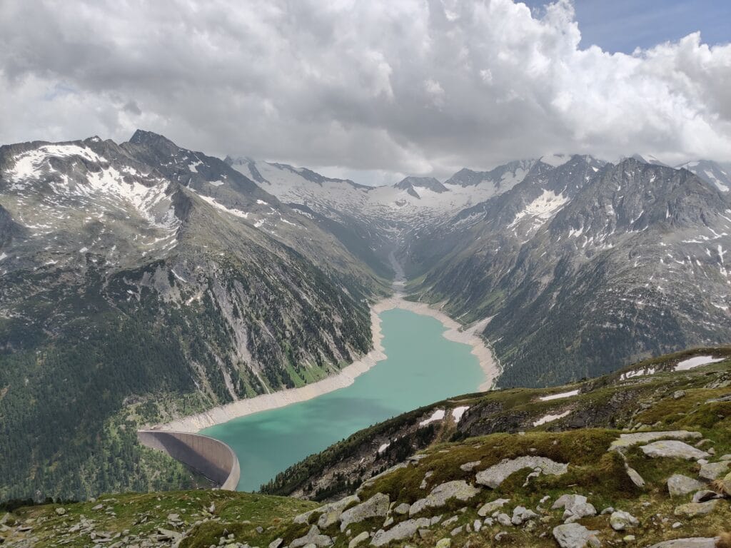
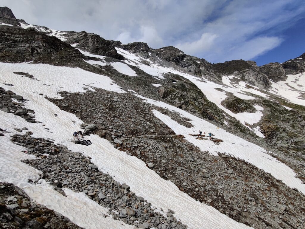
We descended to the Frisenberghaus from the summit and began a short, gruelling climb over rocks and snow. As seen from the images above, in early June, there was lots of deep snow on the trails, and crampons would have been beneficial. Luckily, I felt confident in this alpine terrain and helped my friend Shaun safely navigate the many snow banks. This traverse between Frisenbergahus towards Olpererhutte is high altitude and stunning. With epci views down to the Schelgeis Reservoir, mountain peaks as far as the eye can see, it’s truly worth doing these extensions. At 2700m elevation, the thinner air is noticeable, so we took precautions as we hiked towards the best Schlegeisspeircher viewpoint
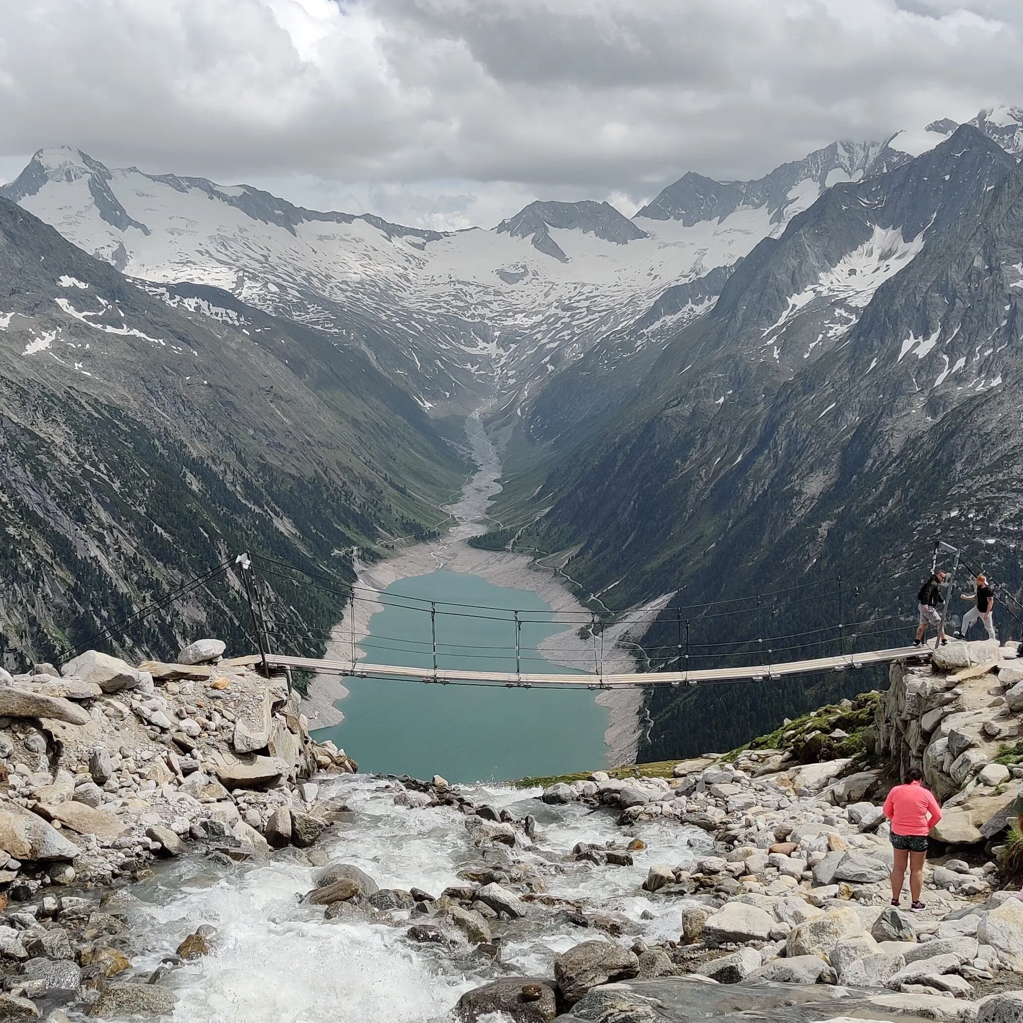
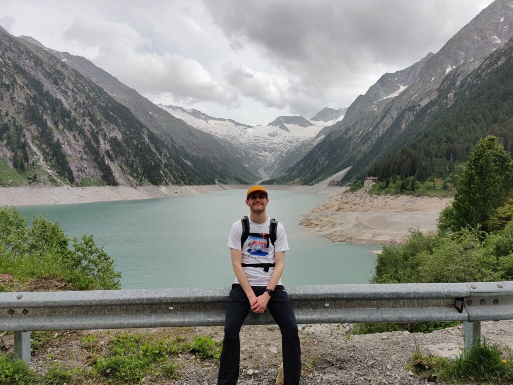
In my opinion, this viewpoint is much nicer as you get a wider view of the reservoir and avoid the crowds a few minutes around the corner. We picked this as the idyllic lunch and photography spot while it was quiet. After hours of peaceful hiking, seeing 5 people in total, we didn’t anticipate how busy the suspension bridge would be and had to wait to cross. We had enjoyed our 13 km hike across technical terrain already and felt rewarded despite the large crowds. It’s worth walking around and up the stream to avoid people directly in your photograph. If you want the classic image of you standing on the bridge, then be patient, as there’s a literal queue.
Schelgeis Reservoir
The crowds were too much in the end. Instead, we started a very fast descent with some trail running down to the Reservoir. This was a steep 3km trail on narrow paths, and I enforced the hiking etquitette of hikers descending should get priority over ascending hikers (who would appreciate the break). We flew down and bombed past other hikers in the hope of catching the next bus. However, we still had 30 mins to wait for a bus due to the irregular departures, yet there are worse places to be waiting. Overall, it’s the best Austrian Alpine hike I have done and would highly recommend Mayrhofen and the Zillertal region for hiking!